Project Summary
Moore’s Gully sits within a 180 Ha multi-stage residential development south of Trinity Beach. Moore’s Gully is a tidally influenced waterway in its lower reaches that channels water from the nearby Macalister Range and outlets through the adjoining Marina.
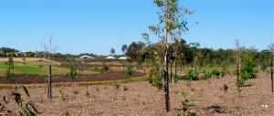
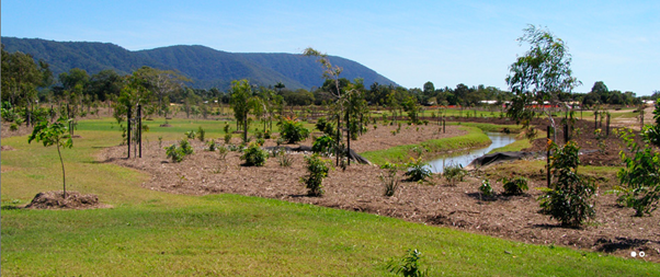
Moore’s Gully was previously a highly disturbed watercourse as a result of sugar cane farming, sand extraction and more recently as a spoil site for Acid Sulphate Soils (ASS) and Potential Acid Sulphate Soils (PASS) from the nearby marina land development. Key aims for the project included providing improved conveyance capacity and flood immunity to the development as well as existing land owners. As a result of employing the philosophy of maintaining and enhancing existing environmental values, Moore’s Gully provides increased ecological diversity and habitats as well as passive recreational facilities (Figure 2).
Size/Type of Project
The project involved realigning and regrading a length of 2.3 km of Moore’s Gully. The design incorporated elements of a natural stream, including sinuosity, low velocity zones and vegetation scour protection, reducing the need for engineered scour protection works. The lower sections of the waterway were re-profiled to increase bank stability and conveyance area.
Substantial revegetation works were undertaken, with the planting of 30,000 native trees, hydroseeding and grass sprigging. Erosion matting was also used in areas of high flow velocities to reduce erosion during the vegetation establishment phase. The revegetation was irrigated and maintained for a period of three years by the developer.
Site Context
The site is within the Bluewater Residential Development, approximately 15 km north of Cairns. The waterway traverses the low lying Moore’s Gully and drains into the Moon River estuary. The lower reaches are estuarine and lie within a Marine Zone (prescribed tidal works area). The site is located in the wet tropics and thus experiences summer dominated rainfall. Flows in the creek range from periods of no-flow to flows of up to 150 m3/s in a 100 year Average Recurrence Interval event. Historically, flooding through the Trinity Beach area in larger rainfall events has been an issue.
Issues and Constraints
A constraints analysis was undertaken resulting in a constraints map. The map was used to optimise the design. The major design and construction issues and constraints included:
- The original design for the development included the construction of a 10 ha lake and major flood retention system. It was recognised that whilst these systems work effectively in temperate areas it was unsuitable to the wet tropics climate.
- As a result, a whole of catchment approach was undertaken and a flood conveyance solution was identified
- The presence of a Major Services Corridor traversing the Moore’s Gully site. This included a sewer pressure main, a water distribution main and fibre optic telecommunication cables
- These limited potential realignment options for the site
- The presence of a fauna corridor between the tidal zone and the existing Trinity Beach Road crossing
- Design and implementation of the landscape and revegetation plan was undertaken in close consultation with the Department of Natural Resources and Water
- There were several deep burial pits and surface spoil for dredged material from the nearby material which contained ASS/PASS material
- Approximately 24,000 m3 of PASS was treated and reused within the development, whilst 6,000 m3 was removed from site as it was not suitable for reuse
Key Practices
- The design incorporated elements of a natural stream, including sinuosity, low velocity zones and vegetation scour protection
- Extensive revegetation was undertaken and included erosion protection during the vegetation establishment phase (Figure 3)
- The design integrated urban features including cycle and pedestrian paths
- Designers worked closely with the environmental authority to ensure environmental integrity was maintained and improved
- for example, design criteria included; banks to have at least five mixed native species, with tree species at 2 metre spacing and beds or benches are to have at least 3 mixed native tree species at 10 metre spacing
- Flood conveyance system tailored for the For North Queensland climate
Costs
The residential area will be developed by private developers. All infrastructure will become donated asset to Council. There will be no direct costs for the development borne by Council.
Ongoing maintenance of the waterway once fully developed will be undertaken by the Council’s Northern maintenance depot. Any maintenance costs will be part of their general budget, with as yet no plans for a specific budget just to maintain the Gully.
Monitoring
Monitoring includes the standard construction monitoring for any development occurring within the Cairns Region. Works around the watercourse will be referred to DNRM as a referral agency.
Sources:
Cairns Regional Council
JCU, 2014: James Cook University, Tropical Sustainable Design Case Studies – Moore’s Gully, viewed 21/08/2014, (http://www.jcu.edu.au/tsd/static/56_Template_PDF_Moores_Gully_ss02072014_Latest_JCU_138636.pdf
Brown Consulting, 2014: Brown Consulting, 2014, Key Projects: Water and Environment Projects Moore’s Gully, Cairns, viewed 21/08/2014